[Page 53]Abstract: Many Book of Mormon students are aware that several locations along Lehi’s Trail through the Arabian Peninsula now have surprising and impressive evidence of plausibility, including the River Laman, Valley of Lemuel, Nahom, and Bountiful. One specific named location that has received much less attention is Shazer, a brief hunting stop mentioned in only two verses. After reviewing the potential etymology of the name, Warren Aston provides new information from discoveries made during field work in late 2019 at the prime candidate for the Valley of Lemuel, discoveries that lead to new understanding about the path to Shazer. Contrary to previous assumptions about Lehi’s journey, Aston shows there was no need to backtrack through the Valley of Lemuel to begin the “south-southeast” journey toward Shazer. It appears that Nephi’s description of crossing the river from the family’s campsite and then going south-southeast toward Shazer is exactly what can be done from the most likely candidate for a campsite in the most likely candidate for the Valley of Lemuel. In light of fieldwork and further information, Aston also reviews the merits of several locations that have been proposed for Shazer and points to a fully plausible, even probable, location for Shazer. The account of Shazer, like Nahom, the River of Laman/Valley of Lemuel, and Bountiful, may now be a fourth Arabian pillar anchoring and supporting the credibility of the Book of Mormon’s Old World account.
And it came to pass that we did take our tents
and depart into the wilderness, across the river Laman.
And it came to pass that we traveled for the space of four days,
nearly a south-southeast direction,
[Page 54]and we did pitch our tents again;
and we did call the name of the place Shazer.
And it came to pass that we did take our bows and our arrows,
and go forth into the wilderness to slay food for our families;
and after we had slain food for our families
we did return again to our families in the wilderness,
to the place of Shazer.
—1 Nephi 16:12-14
At first glance, the two verses in Nephi’s account that mention Shazer offer little expectation that this brief hunting stop might be located on the modern map at all, much less with any confidence. This essay reviews the likely etymology of the name before reporting new discoveries made in late 2019 at the prime candidate for the Valley of Lemuel, finds that ultimately form part of the story of Shazer. Several of the locations discussed have not been pictured previously in Latter-day Saint publications. After weighing the various locations proposed over the years, it concludes that recent explorations seem likely to have bridged the 2,600-year gap between Nephi’s day and our own, yielding a fully plausible, even probable location for Shazer.
Alongside the River of Laman/Valley of Lemuel, Nahom, and Bountiful, Shazer thus becomes the fourth Arabian pillar anchoring and supporting, in the real world, the credibility of the Book of Mormon’s Old World account.
The Etymology of the Name “Shazer”
Along with the other place names in the Lehite account, much attention has been given by commentators over the years into understanding what “Shazer” — a name bestowed by the Lehites upon their first camp after leaving the Valley of Lemuel — may signify. This essay contributes to that discussion by suggesting that the identification of the most plausible location for Shazer has strong implications for the suggestions made to date.
In 1952, while making no attempt at locating it, two scholars published quite different suggestions that have dominated discussions of the etymology of “Shazer” down to the present. The most enduring was the suggestion of Sidney B. Sperry that the name may derive from the Hebrew root šzr, referring to “twisting, intertwining.”1 While [Page 55]it has received only qualified support from other Church scholars,2 this suggestion has become accepted as quasi-authoritative by being incorporated into the footnote for the first appearance of the name in the 1981 and 2013 official editions of the Book of Mormon. Since then, various ideas have sought to explain what the “twisting and intertwining” may have referred to; these have ranged from the shape of the location, for example a twisting wadi (Arabic for a valley or watercourse), to the shape of trees that likely grew there.
The second proposal came from Hugh Nibley, whose first book noted that the Arabic term shajer “is quite common … it is a collective [noun] meaning ‘trees.’” He also pointed out that in Arabic, particularly Egyptian Arabic, the word is often pronounced as shazher, which seems to at least approximate the likely vocalization of the name as it appears in Nephi’s text, surely not an inconsequential point.3 Nibley’s suggestion makes sense, since the group was traveling in Arabia and had just spent a substantial period encamped in a place where Arabic would have been the lingua franca allowing them to engage with locals, both at the valley and now at Shazer.
The probable location of Shazer, as discussed in this essay, now comes into play. Any examination of maps and satellite imagery of any of the candidates will reveal only the common-place meandering of almost all Arabian wadis; there is nothing especially “twisting and intertwining” about their shape. It follows, therefore, that Shazer’s name arose for some reason other than the valley’s contours.
As will be discussed, the leading candidate for Shazer is notable for three reasons: its distance from the Valley of Lemuel, its proximity to mountains where game could be hunted, and its profusion of trees. All these features can be readily discerned in satellite imagery, although they are best appreciated at ground level. This makes it seem very likely that the place name Shazer ultimately derives from its trees, as Nibley had suggested.

[Page 56]IMAGE 1. A vivid pre-Islamic hunting scene showing the use of the bow in nearby Yemen appears in Mohammed Maraqten, “Hunting in pre-Islamic Arabia in light of the epigraphic evidence,” Arabian Archaeology and Epigraphy, vol. 26 (2015), 208–34 [this drawing, one of many illustrations, appears as Fig. 16, p. 224]. Image courtesy of Dr. Mohammed Maraqten, Heidelberg University.
To be sure, the matter may not be that simple. For example, Matthew L. Bowen’s recent paper on the etymology of the Shazer name4 introduces the possibility that Nephi’s text may have also been shaped to produce a chiasm recording emphasis of the place as one that provided food for the group, further suggesting that the name may also link to an Old Arabic term for a “young gazelle,” among the likely animals hunted in that area, both then5 and still today. In any case, Bowen’s suggestions are not necessarily exclusive of Nibley’s — Shazer may have been named by the Lehites to account for both features.
[Page 57]Reaching Shazer from the Valley of Lemuel: The New Findings
The story of Shazer has its beginning at the previous encampment: the Valley of Lemuel. In Nephi’s account, the Lehite group — surely guided by the Liahona that had appeared outside of Lehi’s tent that very morning — departed the Valley of Lemuel by first crossing the River of Laman that flowed through it. Taken in conjunction with the words that immediately follow, telling us the duration of travel (four days) and the direction taken (nearly SSE), this indicates rather clearly that the group’s encampment in the valley had been on the north side of the valley. That is, the river at that point must have been flowing in approximately an east-west direction.
Desert travel using loaded camels is usually reckoned at ranging between 20–25 miles (32–40 km) per day, thus giving us robust parameters whenever the number of days of travel is mentioned by Nephi.6
As part of a larger re-examination of the Lehite exodus from Jerusalem, in 2018 and again in 2019 with a colleague, I conducted new explorations of the area in and around Wadi Tayyib al Ism in the Tabuk province of Saudi Arabia; some of my primary conclusions were published in BYU Studies Quarterly.7 This article concluded that Wadi Tayyib al Ism was the candidate that “most plausibly matches Nephi’s account” of the Valley of Lemuel. In fact, exploration of the entire area within the parameters given by Nephi (the three days’ travel into the wilderness after arriving at the Red Sea recorded in 1 Nephi 2: 5–6) has effectively ruled out any other credible contenders for the valley. That being the case, the oasis within the valley must be considered the most plausible specific site for the Lehite encampment, one that lasted many months, if not a year or longer.
[Page 58]IMAGE 2. A view facing southwards over the oasis in Wadi Tayyib al Ism, the candidate for the Valley of Lemuel. Enclosed within mountains, the valley runs in a roughly east-west direction, beginning further inland and descending to the shore of the Red Sea.
In seeking a holistic understanding of the journey from the valley to Shazer, my 2018–19 explorations of the oasis had two primary objectives. Firstly, were there any locations that could have served as an encampment for more than half a dozen tents?8 Secondly, and more importantly, was it, in fact, possible to travel from the oasis through the surrounding mountains to Shazer on nearly a SE heading as Nephi’s text records?
In both cases, the new discoveries conform with remarkable consistency to Nephi’s account.
1. An Encampment Area in the Valley of Lemuel
While other, smaller clearings nearby cannot be ruled out, on the north side of the valley, one quite large clearing beside the oasis stood out. Its smooth level base made it appear ideal as a safe camp site. Overlooking the valley and its clusters of palms, it is elevated above the flood level (flash floods still occur today) and thus would have sat above the level of the river in Nephi’s day.
[Page 59]IMAGE 3. A large flat area suitable for an encampment sits on slightly higher terrain next to the oasis on its north side. This view faces roughly north.
2. Access Directly Out of the Valley of Lemuel Southeast toward Shazer
Most significantly, there indeed proved to be a valley — only one — leading through the mountains enclosing the valley. Importantly, it is the only feasible route to leave the valley in a southward direction for many miles. Its general direction leads southeast through the mountains to emerge in a broad plain (see image 5) offering a multitude of possible pathways that bring the traveler to the huge Wadi Ifal basin and then to the town of al Bad. Thus, no backtracking at any stage was necessary.
Had Lehi and his group used another valley further inland — i.e., further to the east — there would have been no need to cross the River Laman at that point; of course, such a scenario does not fit Nephi’s straightforward account.
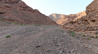
[Page 60]IMAGE 4. After crossing to the southern side of the oasis (across the River Laman in Nephi’s account) this valley is the only one allowing travel through the mountains in a general SE direction. This view faces in the direction of travel.
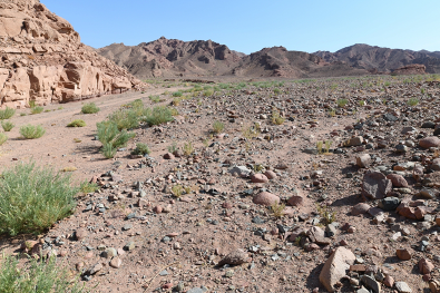
IMAGE 5. The valley exiting the south side of the oasis in Wadi Tayyib al Ism (shown in image 4) arrives at this plain. From there, access through several routes lead southeast in the direction of Shazer.
Finally, whether merely a happy coincidence or not, the valley leading southeast from the oasis lies almost opposite the encampment [Page 61]area, neatly accommodating the Book of Mormon’s description of the particulars of the journey to Shazer. In other words, the group left their campsite, crossed the river, and then immediately entered the one valley permitting travel that would ultimately lead them to Shazer, all the while maintaining the “nearly south-southeast” direction that Nephi recorded. The next verse records their arrival at Shazer.
Taken strictly at face value, Nephi’s stipulation that the journey took 4 days’ travel in nearly a SSE direction to arrive at Shazer can be accepted as both accurate and entirely feasible.
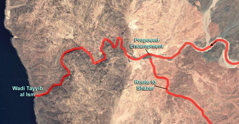
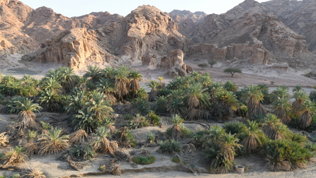
IMAGE 6. Wadi Tayyib al-Ism oasis and the features discussed.
Locating Shazer — The Proposals
Over the years, researchers have proposed several candidates for Shazer. In chronological order these proposals are as follows:
Gulf of Suez Area, Egypt
A 1944 article titled “Lehi’s River Laman” by Ariel L. Crowley in The Improvement Era contained what is probably the first proposal for the location of Shazer ever published.9 Believing that no natural rivers ran into the Red Sea, Crowley suggested that an ancient canal running from one of Egypt’s “Bitter Lakes” through a natural valley, Wadi Tumilat, to the Red Sea near Suez may have been what Nephi referred to. Although the dating remains contested, building of the canal is believed to have [Page 62]begun as early as the 20th century BC before the canal fell into disuse; around 610 BC it began to be restored by Pharoah Necho II.
Crowley went on to hypothesize that the Lehite group then continued their journey to Bountiful along the Egyptian side of the Red Sea, continuing deep into Africa and then east across the Horn of Africa until reaching modern Somalia. In this scenario, therefore, Shazer would lie somewhere near the Gulf of Suez in Egypt.
Unsurprisingly, the logic of this concept was demolished in Hugh Nibley’s 1952 Lehi in the Desert, effectively ruling out a non- Arabian journey,10 but in 1988, Josiah Douglas resurrected and fleshed out Crowley’s idea in a Church News article titled “He [Lehi] May Have Gone Another Way.”11 Douglas went so far as to suggest that Nephi’s Bountiful may be identified with the Nogal Valley in modern Somalia. The article notes Shazer only briefly as a stop at an unspecified place in Egypt “with springs and trees” the requisite 4 days’ travel from the Valley of Lemuel.
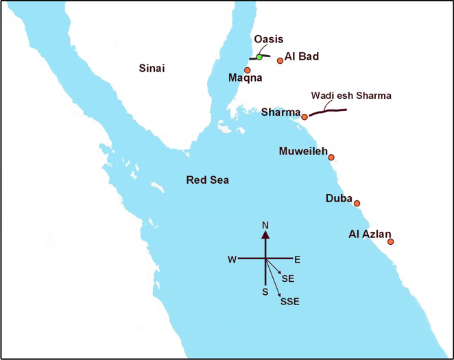
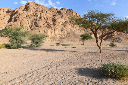
IMAGE 7. The various locations proposed for Shazer in relation to the Valley of Lemuel encampment.
[Page 63]Wadi al Azlan/Wadi al Aznam
In 1976, pioneering Latter-day Saint explorers Lynn and Hope Hilton published the first proposal for the location of Shazer in Arabia.12 Believing the Valley of Lemuel was possibly the vast Wadi Ifal and its ancient Midianite capital, al Bad (al Beda), they suggested that four days’ travel would bring the group to Wadi al Azlan on the Red Sea coast, which they describe as “long an important and large oasis on the Red Sea coastal plain.” They visited water wells in the area and noted that the place was a stretch of “sterile sand” with gently rising “mountains” in the east.
Now more commonly known as Wadi al Aznam, the wells of this oasis have supported a large fort or castle that provided protection for Muslim pilgrims traveling from Egypt and North Africa on one of history’s most important routes: the Egyptian Hajj Road. Al Aznam Fort was built during the 14th century, one of 16 structures that survive to the present along the coastal trail to Medina and Mecca.
IMAGE 8. The oasis at Wadi al Aznam showing the low hills nearby.
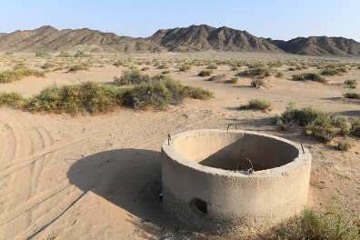
[Page 64]IMAGE 9. One of several water wells, recently enclosed in concrete, at Wadi al Aznam.
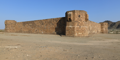
IMAGE 10. The fort at Wadi al Aznam, now restored, helped protect water sources and travelers making the Muslim pilgrimage to Mecca. View taken facing northeast.
As a Shazer candidate, however, Wadi al Aznam suffers from an insuperable difficulty: at some 145 miles (233 km) the distance from the Valley of Lemuel is probably in excess of what a loaded caravan of camels could reach in four days. That remains true even if we regard the Wadi Ifal as the Valley of Lemuel as the Hiltons proposed; accepting[Page 65] Wadi Tayyib al Ism as the valley only compounds the matter, for then closer to seven–eight days’ travel would be required. The fact that only low hills lie nearby, where prey is unlikely to have been present, rather than true mountains, is also an impediment to considering it as Shazer. Substantially better possibilities exist.
Wadi al Muwaylih/Wadi al Muweileh
Twenty years later, in the 1996 update of their original book, the Hiltons made a new proposal, suggesting that Wadi al Muwaylih, located considerably closer to al Bad, was a promising location for Shazer. Making no reference to their original proposal, their book describes the new candidate as the terminus for Wadi Sirr (or Wadi Surr), an “amazing desert oasis covered by at least eighty acres of date palms … close to the Red Sea beach.”13
Now more commonly presented in maps and on signage as Wadi al Muweileh, the fort here is larger than at Wadi al Aznam but belongs to the same era and follows the same style. Adjacent to the fort, large areas of date palms grow, both along the coast and stretching inland. As image 13 shows, the mountains, however, are a considerable distance further inland.
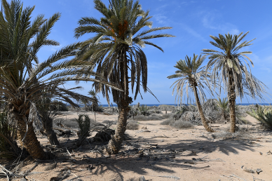
[Page 66]IMAGE 11. Palm trees reach the Red Sea coast at Wadi al Muweileh.
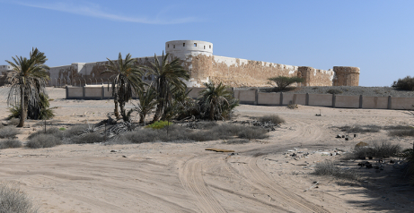
IMAGE 12. The restored fort at Wadi al Muweileh.
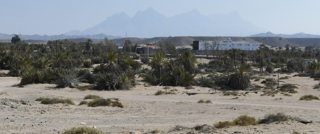
IMAGE 13. Palm trees extending inland at Wadi al Muweileh toward the distant mountains.
Wadi al Muweileh is a substantially more attractive candidate for Shazer than Wadi al Aznam; it has a larger fertile area that continues to allow date palms and other crops to grow, and its distance from the Valley of Lemuel (about 88 miles [142 km]) could be reached in four days. However, as it lies on the Red Sea coast the distance inland to reach mountains where game might be hunted is substantial.
If no other locations in the area met Nephi’s description, it could be considered a candidate for Shazer, but with the reservation that it lies distant from any opportunities for hunting.
[Page 67]Wadi Agharr/Wadi esh Sharma
Fortunately, a third proposed location for Shazer exists that lacks the difficulties of the others. In 2003, Latter-day Saint expats George Potter and Richard Wellington reported a major valley named Wadi Agharr that reaches the Red Sea near the town of Sharma. While two main areas of oasis are present today, one in the narrowest section near the coast and one further inland where the wadi widens, they noted a traveler’s account from less than a century ago that described the date palms extending over a distance of 15 miles (24 km).14
More commonly now known as Wadi esh Sharma, the wadi stretches inland a considerable distance with low mountains close on both sides initially and then later broadens considerably. The most fertile and vegetated area west of the wadi is now commonly known as Wadi esh Sharma or simply Wadi Sharma; some of it stretches further inland and often appear on maps under names such as Wadi Arab and Wadi al Alas.
Since Shazer is mentioned only as a stop where hunting took place, it is of great interest that locals living in the valley today have confirmed the ongoing presence of game such as ibex in the surrounding mountains.15
While access into the wadi is easily made from the Red Sea coast, it is perhaps more likely that the Lehite group entered via a short wadi that leads straight from Wadi Ifal and intersects Wadi Sharma, as seen in image 14.
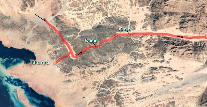
[Page 68]IMAGE 14. Wadi esh Sharma can be readily accessed from the Valley of Lemuel through the short wadi, an extension from Wadi Ifal, seen here in red. The two main oasis areas in Wadi esh Sharma can be easily seen. Image courtesy of Google Earth.
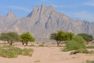
IMAGE 15. These impressive mountains face the traveler in Wadi Sharma near the easternmost oasis. This view was taken facing eastwards near the easternmost oasis.
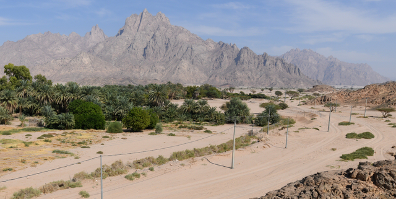
[Page 69]IMAGE 16. A panoramic view of the easternmost oasis in Wadi Sharma, facing eastwards. The continuation of the wadi inland is visible to the right of these mountains.
Wadi esh Sharma thus meets Nephi’s account in ways that no other location does. At about 70 miles (110 km) from the Valley of Lemuel, it easily fits the description of being four days’ travel, is readily accessible, and provides a pathway further into the interior of Arabia. It alone has the oasis resources of water and crops, especially the ubiquitous date, that a traveling group would find valuable, but also mountains in the immediate vicinity that would have hunting opportunities, as they do today. This precise match to the text makes it the most plausible location for Shazer by far.
Conclusions
As the initial stage of the Lehite journey leading to the ocean crossing and arrival in the New World, the land locations discussed here are of no little importance. They represent an enormous investment of energy and time by researchers over many years to provide the Nephite record with a firm footing that assures potential readers that the account is authentic history.
As we begin the 2020s, we can look back and see in detail how each stage of the Arabian crossing of that journey of journeys is now plausibly situated. At almost the beginning of that journey, the impressive Valley of Lemuel and River of Laman stand without credible challengers; similarly, as discussed here, Shazer can now be identified with a high degree of certainty.
[Page 70]Nahom, marking the burial place of Ishmael and the major change in travel direction has, uniquely, inscriptional support for the name that dates to the correct period.16 The final, most difficult leg across Arabia saw the group eventually arrive in Bountiful, a place “prepared of the Lord” with all the resources required to build a ship that could cross oceans. Here we currently have two relatively nearby candidates in southern Oman, one of which, Khor Kharfot, is accepted by many researchers, while the other, Khor Rori, also has notable champions.17 Over time, we can expect that this dichotomy will be resolved.
Going forward, there is of course more to do. For the Arabian journey, more needs to be done to define the journey from Shazer to Nahom, about which the text says very little. When conditions allow researchers to return to Yemen, additional work is needed in further comprehending this region and what transpired there.
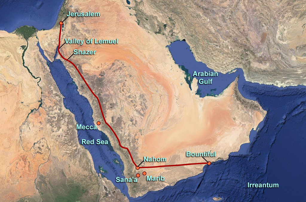
IMAGE 17. The entire Lehite route across Arabia as currently established, showing the origin point, Jerusalem, in addition to the 4 pillars discussed in this article.
[Page 71]The process of consilience takes place when evidence from unrelated and independent sources converge. When that happens, the resulting conclusions move beyond being mere claims; they become substantial and significant, requiring the observer to consider the strong likelihood that they are objectively true.
From the standpoint of the Book of Mormon’s Old World setting, the emergence of candidates for each specific location in Nephi’s text — plausibly and precisely situated from all perspectives — surely qualifies as an example of this. Of the four “pillars” of credibility discussed here, Shazer stands as the most recent illustration of this process unfolding.
Can we hope that these Old World pillars will now begin to contribute towards a resolution of the New World setting? Better understanding of the bridging events between these two worlds — the ships used in the various migration voyages and the ocean routes taken — may become keys to moving us ahead. If so, the Book of Mormon would then be positioned to emerge anew in its full real-world setting, ready to impact a vastly greater audience.18
[Author’s Notes: My 2019 exploration in the oasis area of the Valley of Lemuel and the various Shazer candidates was facilitated and greatly enhanced by the contributions of my traveling companion, Jon Nelson. This article also benefited greatly from the comments made by three anonymous reviewers. The color images in this article are by the author and were made without filters or digital enhancements. They may not be reproduced without written permission.]


Warren P. Aston is an independent researcher based in Brisbane, Australia. Since 1984 his exploratory efforts throughout the Near East and Mesoamerica have identified the candidates for “Nahom” and the Old World “Bountiful” now accepted by most Latter-day Saint scholars. In 2013 he co-founded the Khor Kharfot Foundation, leading several international teams undertaking fieldwork at the site. He is the author of In the Footsteps of Lehi (1994); Lehi and Sariah in Arabia: The Old World Setting of the Book of Mormon (2015) and numerous papers and articles. Warren’s findings have been reported in Church Education System manuals, BYU Studies Quarterly, Encyclopedia of Mormonism, and the Journal of Book of Mormon Studies. They have also been presented at non-Latter-day Saint forums such as the annual Seminar for Arabian Studies in the UK and in publications such as the Journal of Arabian Studies. His work continues in both Arabia and Mesoamerica, including a major Book of Mormon Central exploratory project focused on the hill Ramah/Cumorah.
7 Comment(s)
Theodore Brandley, 08-23-2020 at 10:53 am
The good work in Arabia by Warren Aston and others has produced compelling empirical evidence for the veracity of The Book of Mormon, which is accepted by almost all LDS scholars, and members who are aware of it. This work also demonstrates that the Lord inspired His prophets to include in the text all of the clues required for us to know all of the major locations of The Book of Mormon, from Costa Rica, to Central Guatemala, to Northern Mexico, to the Mississippi River, to the Midwest and East Coasts of the United States, and to the State of New York. This kind of meticulous work of matching the text to the facts on the ground, if applied without sundry false assumptions, can produce the same compelling empirical evidence in the North American Continent as it has done in Arabia.
Theodore Brandley, 08-22-2020 at 4:51 pm
Warren Aston, you did it again! More great investigation, exploration, research and reason. Four pillars established and mission accomplished.
Your next mission, should you choose to accept it, is to go to center of the west coast of Costa Rica and find the remains of the temple built by Lehi and family upon their arrival in the Promised Land. This temple will be similar to the one they built during their stay in the Arabian Bountiful and will be located near the sea and above a river emptying into the sea. According to the US Geological Survey, this is the only location along the west coast of North America where gold, silver and copper are found all within a radius of 30 miles (1 Nephi 18:25).
This message will self-destruct if you choose to ignore it.
Replies
James Warr, 08-26-2020 at 8:27 pm
Mr. Brandley, I would be interested to know where you got your information on Costa Rica and it’s mineral deposits. Jim Warr
Replies
Theodore Brandley, 08-27-2020 at 10:15 am
Jim Warr,
When I did this research in 2007, the known mineral deposit location maps were located at http://minerals.usgs.gov/minerals/pubs/country/latin.html#mx However, these maps are no longer at that URL. I have emailed the USGS to help me recover them and will get back to you on their response.
Costa Rica has all the other features Nephi described (1 Nephi 18:24-25). They planted all their seeds in the earth and they “did grow exceedingly.” Costa Rica has fertile soil and 150 inches (3.8 m) of rainfall per year. It is interesting that the almond tree is indigenous to the Levant and is mentioned ten times in the Old Testament, but the almond is also considered to be native to Costa Rica. In Costa Rica the almond tree is larger, but the fruit appears and tastes almost identical. After 2500 years growing wild in an entirely different climate, I think it could have mutated to that extent to adapt. A plant geneticist could probably analyze the differences and determine that. Perhaps there are other plants in Costa Rica that could have originated in the Levant?
The most probable point for Lehi and his family to land would have been on the lush coastal strip where the fresh water of the Rio Grande Tárcoles River flows into the Gulf of Nicoya, near the present town of Tárcoles. When Lehi left Jerusalem, the first place he camped was beside a river of fresh water where it emptied into the Red Sea. The place Lehi sailed from was a fruitful valley near the sea they called Bountiful. When they landed in the Promised Land, they surely would have settled along a fresh-water river, not far from the sea. They may have sailed a short distance up the Rio Grande Tárcoles and found a good settlement site on the rich flat soil on the north bank of the river. After eight years in the desert and traveling more than half-way around the world by sea, the tropical paradise of Costa Rica would have been an unimaginable fulfillment of the promised blessing to Lehi and his family.
Theodore Brandley, 09-29-2020 at 2:25 pm
James,
After contacting USGS they finally provided me with the links to the following:
Mineral Resources Data System (MRDS) By Commodity
https://mrdata.usgs.gov/mrds/map-commodity.html
It is an interactive map where you can select the mineral you are looking for anywhere in the world. It is greatly improved from what I was using twelve years ago. Here is a link to an area about 25 miles from my suggested Lehi Landing Site:
Quebrada Curtiembre Prospect
Occurrence in San Jose, Costa Rica with commodities Lead, Zinc, Copper, Silver, Gold
https://mrdata.usgs.gov/mrds/show-mrds.php?dep_id=10090473
Robert F. Smith, 08-22-2020 at 2:20 pm
Another great contribution to our realistic knowledge about the Book of Mormon. I love your work, mate.
James Warr, 08-22-2020 at 11:16 am
Good and informative research. Keep up the good work Warren.